20 Things to Do in Death Valley National Park
Death Valley National Park is one of the most fascinating parks I’ve ever visited. It’s easily in my top five — and a place I think everyone should experience at least once, even if you don’t consider yourself a “park person.”
It’s huge, hot, and rugged, and most people don’t realize how much of it you can actually see with a standard car. The key is knowing where to go — because everything is spread far apart and not all of it requires hiking or 4WD.
If you’ve got a day (or ideally a few), these are the best things to do in Death Valley National Park that you can reach without a high-clearance vehicle.
Things to Do in Death Valley National Park
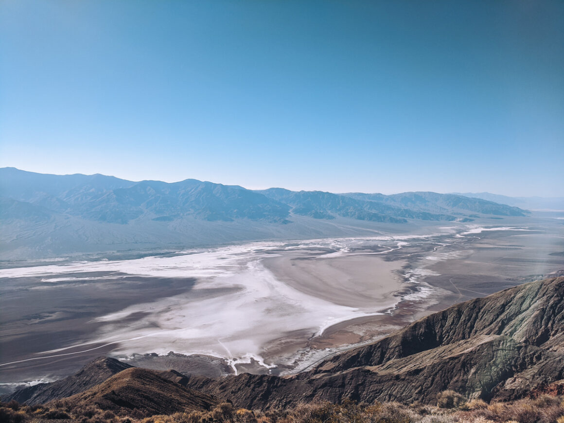
1. See Dante’s View
If you enter from the east or drive to Death Valley from Las Vegas, Dante’s View should be one of the first stops you make in the park. Not only is it one of the best things to do in Death Valley National Park but it’s the perfect introduction to the park, its surroundings and terrain.
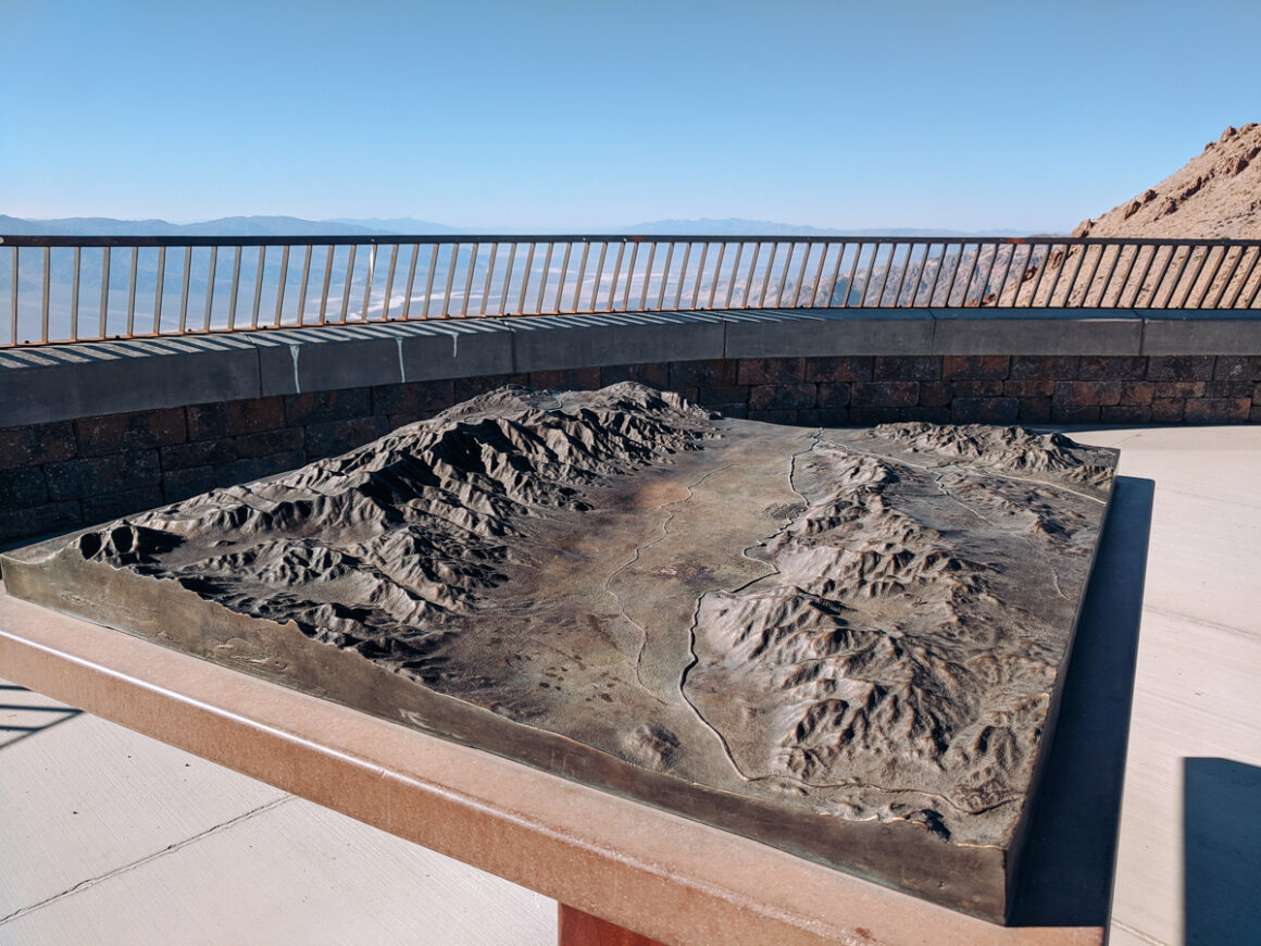
At 5,500 feet above sea level, the view from here is a gorgeous, panoramic vista of the Badwater Basin area and the mountain ranges. It also features an informative topographical map of the Death Valley to help visualize just how impressive this area of the country is.
Just below the the viewpoint lies the salt flats — the park’s lowest point. Across the flats to the west is the Panamint Mountain Range with Telescope Peak — the highest point in Death Valley National Park. That means from this unique vantage you can see both the lowest point in Death Valley and the highest point at the same time.
How to Get There
- Road / Highway: Dante’s View spur off CA-190
- Vehicle Restrictions: Vehicles longer than 25 feet not allowed; trailer parking available at entrance
- Parking: Small lot at the end of the road
- Best Time to Visit: Early morning for best light and fewer crowds; sunset is popular but arrive early for parking
- Tips / Notes:
- Bring a jacket (higher elevation means cooler temps and wind)
- Check road conditions in advance
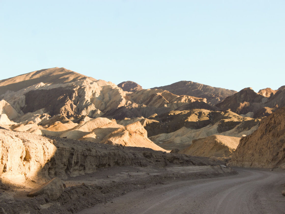
2. Drive 20 Mule Team Canyon
Since the 1870’s, white gold — or borax — has been mined in the mineral rich Death Valley region. In the past, the only way to transport the borax out of the valley was in wagons — pulled by teams of eight or ten team horses and mules. Even with that many animals, they struggled to move the wagons in the harsh valley conditions.
To compensate, one creative miner came up with the idea of combining two ten-mule teams to haul the borax out of the valley. And voila — the 20 Mule Team name was born. Over the years, mule teams carried millions of pounds of borax out of Death Valley and the name “20 Mule Team” became so popular, it still appears boxes of Borax today.
Death Valley’s 20 Mule Team Canyon isn’t the exact route that was used by the mules teams on their journey out of the valley but it’s similar. Driving through the canyon gives you an idea of the difficulties the mules and drivers faced back then. Imagine spending — at minimum — ten days with a team of mules — and not in your air conditioned car — in one of the hottest, most dangerous parts of the country.
How to Get There:
- Road / Highway: CA-190
- Vehicle Restrictions: Unpaved road, generally passable in standard vehicles in dry conditions
- Parking: Small parking area at the trailhead/entrance
- Best Time to Visit: Early morning or late afternoon for best light and cooler temperatures
- Tips / Notes:
- The road is one-way
- Avoid after heavy rain
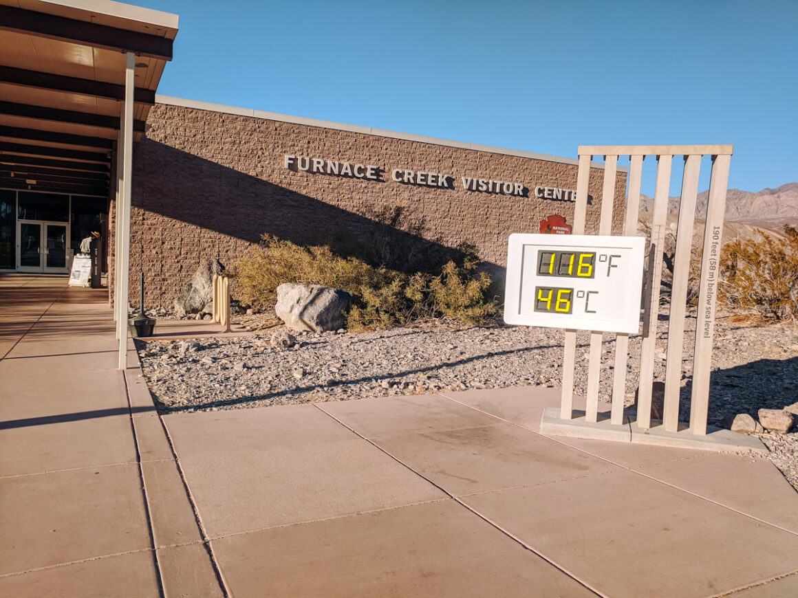
3. Stop by Furnace Creek Visitor Center
A stop at the Furnace Creek Visitor Center is a must and another good introduction to Death Valley National Park. Plus, it’s the best way to stay informed about what’s going on in the park or any closures. You can pick up maps, chat with rangers and learn about programs or special events going on.
One of the park’s most photographed attractions is also located here: the official Death Valley thermometer, which monitors the temperatures across the park. Even if you’re just driving through the area, seeing the thermometer is a fun experience and one of the must-see things to do in Death Valley National Park.
How to Get There
- Road / Highway: CA-190
- Vehicle Restrictions: None; standard vehicles are fine
- Parking: Shaded parking available at the visitor center
- Best Time to Visit: Anytime during operating hours, 8 am – 5 pm
- Tips / Notes:
- Stop here for park information and bookstore
- Restrooms and water are available
- Get your National Park Passport Stamped
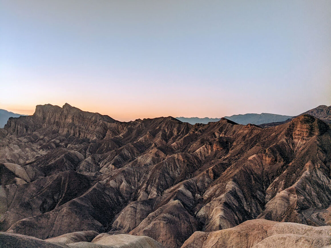
4. Zabriskie Point at Sunset
Hands down, spending time at Zabriskie Point is one of my favorite things to do in Death Valley National Park. Located in the Amargosa Range of the park, Zabriskie Point is full of colorful landscapes made up of sediment from Furnace Creek Lake — a lake that dried up long before Death Valley as we know it came into existence.
Zabriskie Point is gorgeous any time of the day but it’s really beautiful at sunset. As the evening light intensifies, the different colors and hues come out, with a glow that softens the peaks and valleys. It’s the ideal place to sit and relax after a long hot day. The overlook has a wall that you can perch on but I suggest bringing a chair and a snack or beverage.
How to Get There
- Road / Highway: CA-190
- Vehicle Restrictions: None; standard vehicles are fine
- Parking: Large lot at the trailhead
- Best Time to Visit: Sunset for the best colors; early morning is quieter
- Tips / Notes:
- The walk to the viewpoint is slightly uphill
- Excellent spot for panoramic views of the badlands
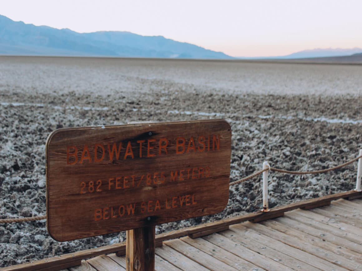
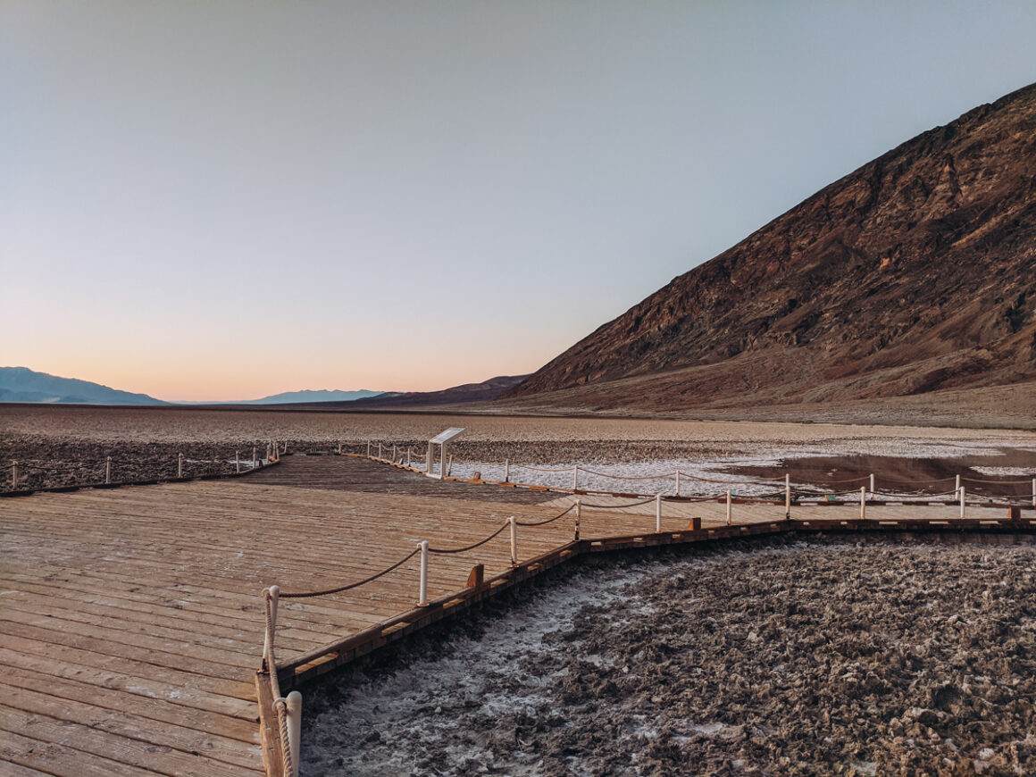
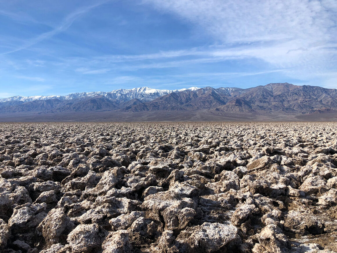
5. Badwater Basin Salt Flats
Created by movements in the earth’s crust, Badwater Basin is one of the most well-known sites in Death Valley National Park. At 282 feet below sea level, it’s the lowest point in North America. In wetter climates, this area would be covered by water but in Death Valley’s dry heat, rainfall evaporates quickly and leaves behind the crusty shapes in the salt flats.
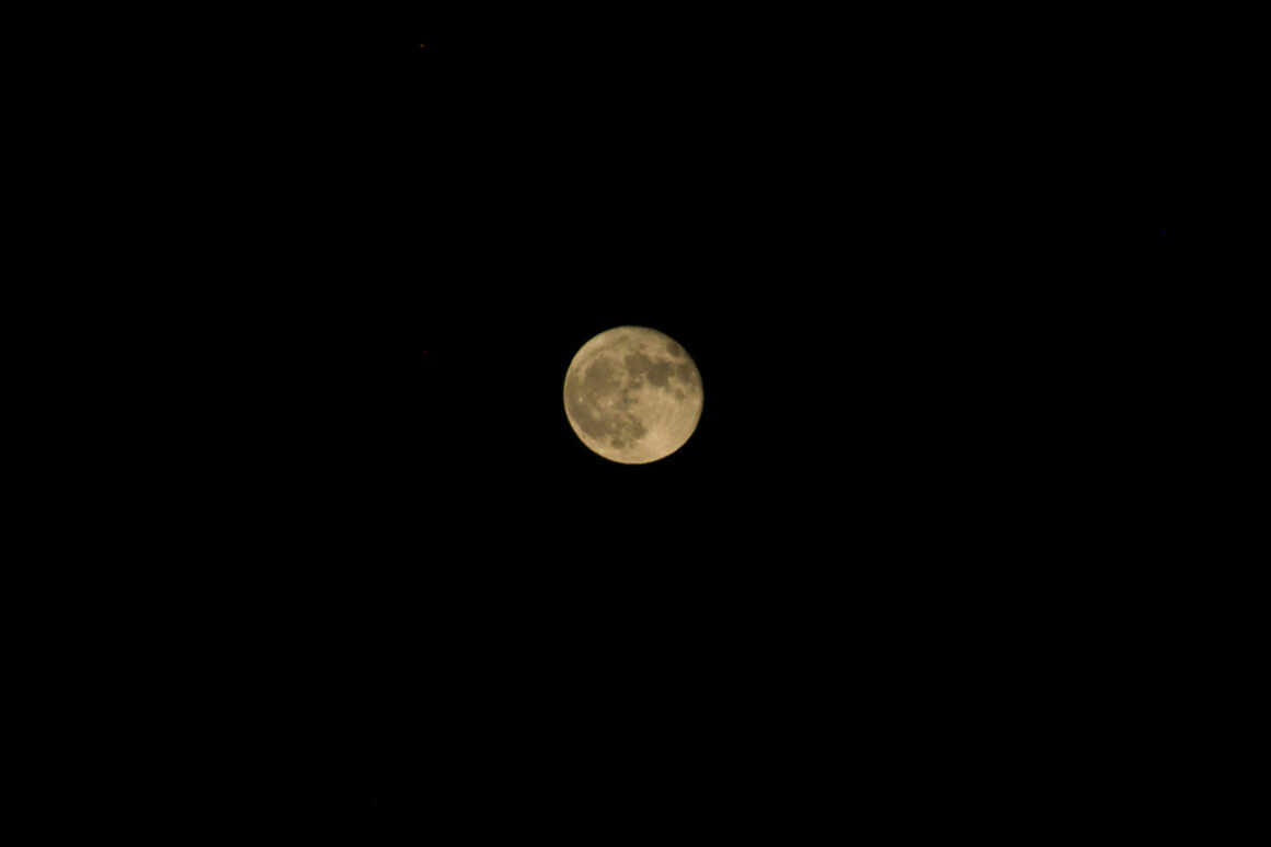
While there is an assessible wooden boardwalk and a viewing platform, the best way to experience the flats is by walking out onto them. The further you go, the fewer people you’ll encounter and the larger the salt patterns become. Badwater is also a top spot for sunrise, sunset, or even a full moon, when the white salt appears to glow in the moonlight.
In the last couple of years, Death Valley has seen the return of Lake Manly — a rare and temporary lake that forms in Badwater Basin after more rainfall than normal. When it appears, it draws large crowds. When I visited in December 2025 the lake was there it was so busy. The parking lot was full and many people were parking along Badwater Road.
If you visit during one of these rare periods, bring your patience, allow extra time for parking and expect heavier foot traffic than usual. It was windy the day I was there so I wasn’t able to get much reflection off the water but it was an amazing sight to see. I highly recommend visiting while you can.
How to Get There
- Road / Highway: Badwater Road off CA-190
- Vehicle Restrictions: None; standard vehicles are fine
- Parking: Large parking lot onsite
- Best Time to Visit: Sunrise or sunset for the best light and fewer crowds; May through October for more defined salt patterns
- Tips / Notes:
- Restrooms are available at the parking lot
- Walking out onto the flats is optional but highly recommended
- Consider visiting on moonlit nights for a unique experience
- Look for the sea level sign on the rocks above the parking lot
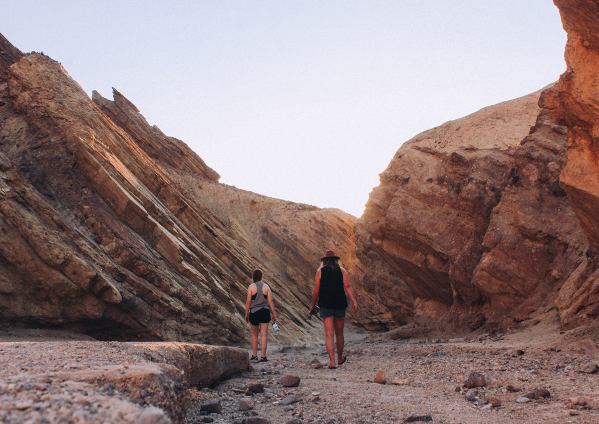
6. Hike Golden Canyon
Hiking in Death Valley’s heat can be challenging, but the Golden Canyon Trail is one trail that’s worth it – especially in the cooler hours of the day. The trail winds through unique geology and rock formations and leads to one of the park’s most striking features, Red Cathedral.
The full hike is about 3 miles round trip, but if temperatures are high, you don’t have to go all the way. Turn around whenever you feel comfortable – the trail is just as beautiful on the way back. In the evening, the rocks take on vibrant colors as the sun sets, making it feel as if someone has flipped a light switch on the canyon walls.
How to Get There
- Road / Highway: Access via Badwater Road
- Vehicle Restrictions: None; standard vehicles are fine
- Parking: Parking lot at the trailhead with vault toilets
- Best Time to Visit: Early morning or late afternoon to avoid the heat
- Tips / Notes:
- Wear sun protection and sturdy shoes
- You can turn around at any point
- Sunset transforms the canyon walls into glowing shades of red and gold

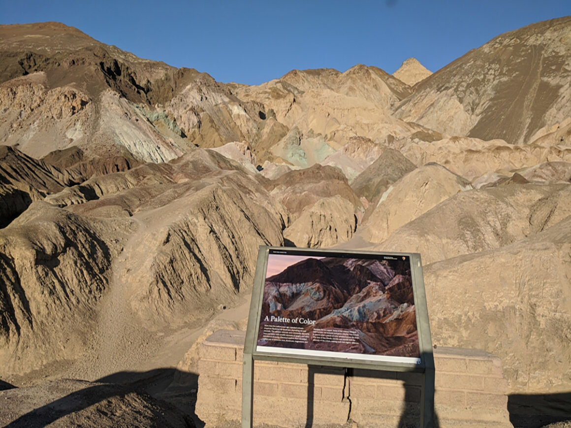
7. Artist’s Drive & Artist Palette
Artist’s Drive is one of the most popular scenic drives in Death Valley National Park — and one of the easiest ways to experience the park without leaving your car for long.
This one-way paved road winds through hills painted in a striking array of colors, caused by volcanic deposits rich in minerals like iron oxides and chlorite. The result is a landscape that looks almost unreal — with shades of red, orange, yellow, pink and even green depending on the light.
About halfway along the drive, you’ll reach Artist Palette, the most well-known section. There’s a small parking area where you can get out and walk into the hills.
This is one of the most photographed spots in the park but the intensity of the colors can vary. If the ground has had recent moisture, the colors tend to be more vivid. In drier conditions, they may appear more muted — but it’s still worth the stop.
This is an ideal addition to your day when temperatures are high or if you’re focusing on stops that are easy to access by car.
How to Get There
- Road / Highway: Artist’s Drive off Badwater Road
- Vehicle Restrictions: No RVs, buses, or trailers over 25 feet
- Parking: Small parking lot at Artist Palette; multiple pullouts along the drive
- Best Time to Visit: Early morning or late afternoon for the best light and color intensity
- Tips / Notes:
- Colors vary depending on light and recent rainfall
- Great option for hot days when hiking isn’t practical
8. Devil’s Golf Course
While you won’t be teeing off here, Devil’s Golf Course is a must-see in Death Valley National Park. This vast expanse is covered with jagged rock salt that has been eroded by wind and rain, forming sharp, rugged mounds. So rugged, in fact, that it’s said “only the devil could play golf on such rough links.”
The salt crystals also expand and burst in the heat, creating an eerie popping sound you can hear as you walk around the edges of the formations.
How to Get There
- Road / Highway: Badwater Road
- Vehicle Restrictions: Suitable for most vehicles, including passenger cars
- Parking: Gravel lot near the formations
- Best Time to Visit: Early morning or late afternoon to avoid the heat
- Tips / Notes:
- Wear sturdy shoes if you plan to explore near the salt
- Don’t drive onto the formations
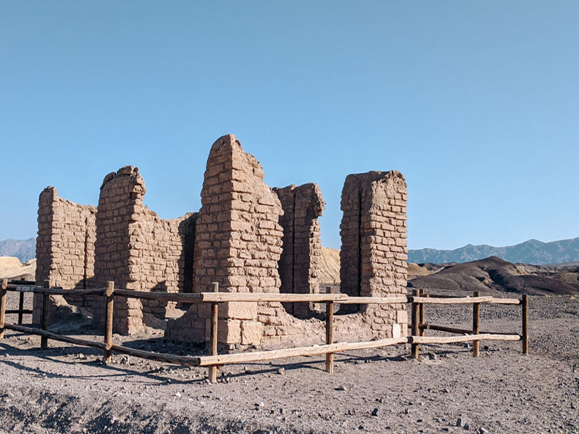
9. Check Out Harmony Borax Works
Harmony Borax Works, built in 1881, played a key role in the development of the Furnace Creek area after borax was discovered. At its peak, more than forty men worked here processing the ore to extract borax. The company famously used the 20 Mule Team wagons to transport the mineral out of the valley.
The plant was short-lived, closing in 1888, but remnants of the original buildings and mining equipment remain, offering a fascinating glimpse into Death Valley’s mining history.
How to Get There
- Road / Highway: Mustard Canyon Drive off CA-190
- Vehicle Restrictions: Gravel road suitable for most vehicles
- Parking: Small gravel lot onsite
- Best Time to Visit: Morning or late afternoon to avoid the heat
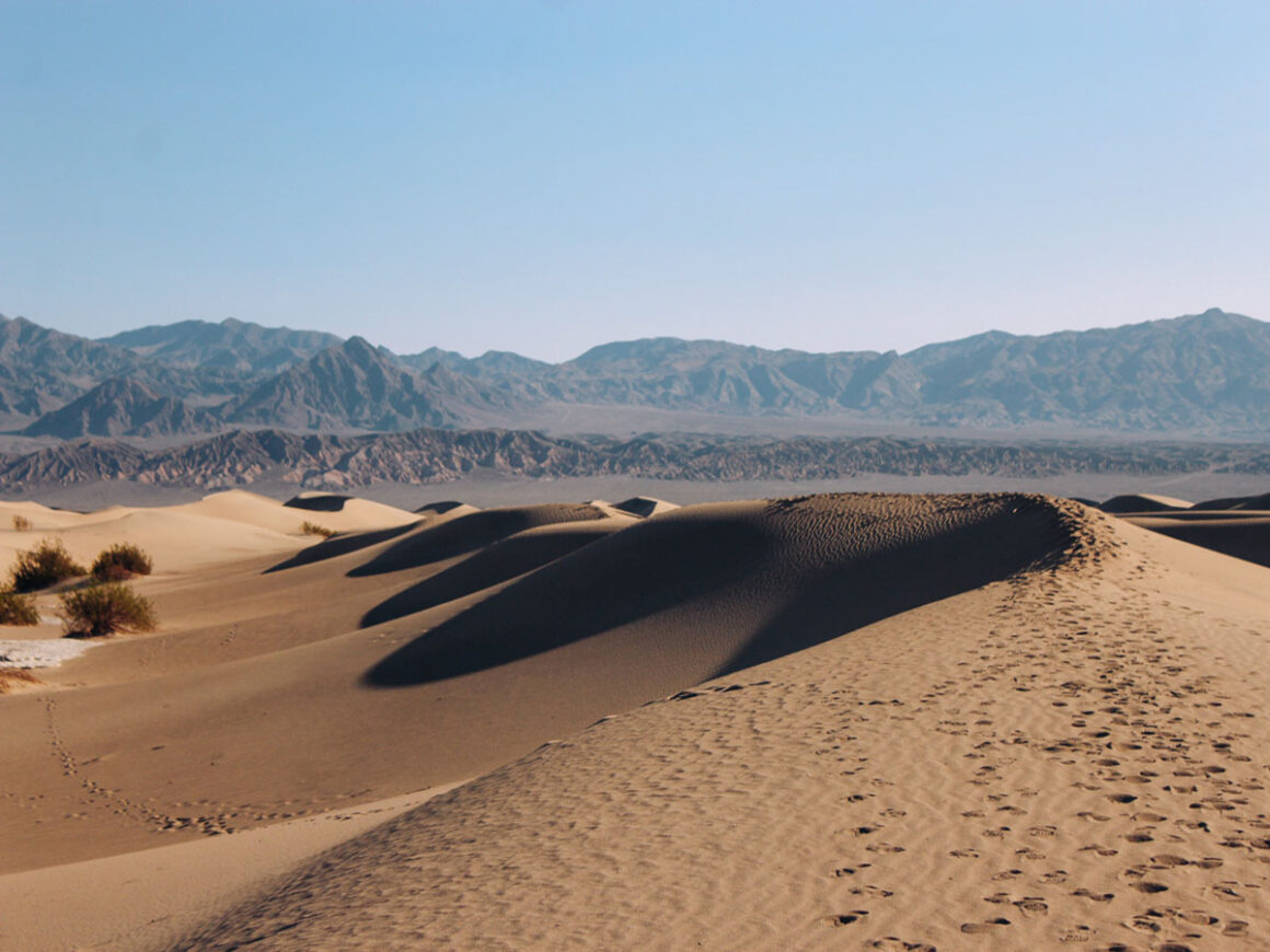
10. Play on Mesquite Flat Sand Dunes
One of the most fun things to do in Death Valley National Park is exploring the sand dunes and Mesquite Flat Sand Dunes is the most accessible dunes for passenger cars.
These dunes were shaped over centuries by constant wind and erosion. You’ll find crescent, linear and star-shaped dunes, with the highest point accessible via a roughly 2-mile out-and-back hike. While you can hike to the top, it’s not necessary to enjoy the magical views of the dunes.
Star Wars fans may recognize this area as the dunes of Tatooine. No droids here but early morning visits offer cooler temperatures and a chance to see wildlife like sidewinder rattlesnakes, though encounters are rare.
How to Get There
- Road / Highway: CA-190
- Vehicle Restrictions: Accessible by passenger car
- Parking: Large parking lot onsite
- Best Time to Visit: Early morning for cooler temperatures and softer sand
- Tips / Notes:
- Sunrise provides the best light for photography
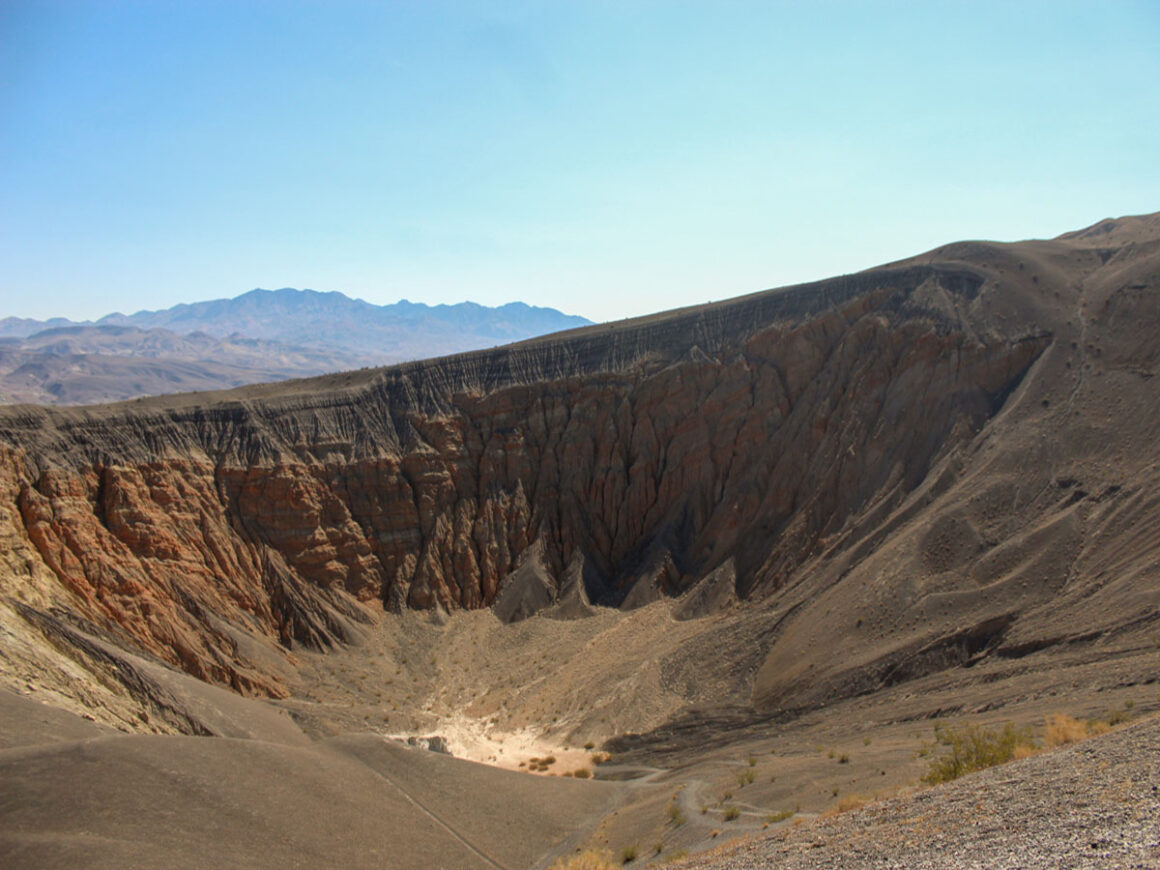
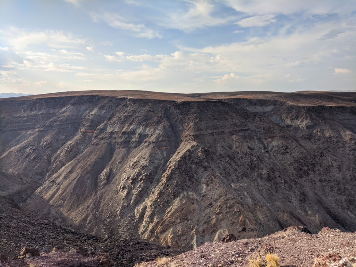
11. Wander Around Ubehebe Crater
If I had to pick a favorite thing to do in Death Valley National Park, Ubehebe Crater would be in the top three. The massive crater is stunning. It was formed when hot magma rose to the surface and met underground water, causing a violent steam explosion.
The main crater is about 600 feet deep and half a mile wide. That’s huge — and it’s difficult to capture the entire crater without a wide-angle lens. Visitors are allowed to hike down into the crater if they’re feeling adventurous, but climbing back up is a challenge.
The walk from the parking lot to the crater rim is a short uphill stroll on a paved path. The rim trail is about 2.2 miles and features loose volcanic rocks, so closed-toe shoes are essential. Within walking distance, you can also explore smaller craters, including Little Hebe Crater.
How to Get There
- Road / Highway: Scotty’s Castle Road (paved, but can close during or after rain)
- Vehicle Restrictions: Standard passenger vehicles
- Parking: Lot at the crater
- Best Time to Visit: Early morning or late afternoon to avoid heat and capture better light
12. Drive Wildrose Canyon & Have a Picnic at Wildrose Station
Wildrose Canyon is a fun scenic drive in Death Valley National Park that can usually be done by car if the road is open. This route climbs up into the Panamint Range and offers a completely different landscape than the desert floor below. As you gain elevation, temperatures drop and the scenery shifts into wider and flatter views across the valley.
Along the drive, one of the best places to stop is Wildrose Station. Once a privately owned stagecoach stop, with a nearby spring, it served as a watering point and rest area for travelers moving through the mountains. Today, a few palm trees and picnic tables mark the site, making it a great place to take a break from driving.
This is one of the more peaceful picnic spots in the park, and you may even spot wild burros in the area, many of them descendants of mining-era animals that still roam the region. It’s a simple stop, but it adds a quieter, more reflective moment to a Death Valley itinerary that’s often focused on big viewpoints and dramatic landscapes.
How to Get There
- Road / Highway: Turn off Highway 190 near Panamint Springs onto Panamint Valley/Trona Wildrose Road, then left onto Wildrose Road
- Vehicle Restrictions: No RVs, buses or trailers over 25 feet
- Parking: Pullouts along the route for photos and short stops
- Best Time to Visit: Early morning or late afternoon for cooler temperatures and better lighting
- Tips / Notes:
- The road can flood easily — avoid during/after rain
- Watch for wild burros but do not feed them
- Google Map
14. See the Wildrose Charcoal Kilns
Another remnant of Death Valley’s mining history can be found in the Wildrose area: the Wildrose Charcoal Kilns. Built in the late 1800s by a mining company, the kilns were used to produce charcoal as fuel for smelters, which extracted metal from ore. Ten kilns remain standing today, making them some of the best-preserved examples in the western United States.
How to Get There
- Road / Highway: Emigrant Canyon Road
- Vehicle Restrictions: Last 2.1 miles are unpaved but passable for most passenger vehicles
- Distance: 28 miles from Highway 190
- Parking: Small lot near the kilns
- Best Time to Visit: Morning or late afternoon for cooler temperatures
- Tips / Notes:
- Bring sunscreen and a hat
- Explore the area carefully; uneven ground near the kilns
Don’t forget a Death Valley National Park guidebook! For years Moon Travel Guides have been my go-to source for all things travel. Their park guides are so helpful and written by authors who spend a lot of time in the parks they write about. I’ve linked to Moon Death Valley National Park guide here.
15. Stop By Father Crowley Vista Point
Death Valley National Park is full of jaw-dropping views but by far one of the best in the entire park is Father Crowley Vista Point. Named after the Catholic priest, who ministered to the people of Inyo County (California), his parish included the lowest point in the country, Death Valley and the highest, Mt. Whitney.
The main feature at this viewpoint is Rainbow Canyon, a colorfully striped canyon formed by volcanic activity. In recent years, it was sometimes called Star Wars Canyon because the military used it for fighter jet training until a crash in 2019 ended those flights.
How to get there:
- Road / Highway: CA-190
- Vehicle Restrictions: None
- Best Time to Visit: Morning or late afternoon for best lighting
- Parking: Ample parking at the overlook
- Tips / Notes:
- Restrooms available
- Look for the Father Crowley mural in Lone Pine, CA
16. Go Stargazing
Far away from the light pollution of major cities, Death Valley National Park has some of the darkest skies in the United States and is designated as a Gold Tier International Dark Sky Park award is reserved for areas with exceptionally dark night skies.
On nights when the moon isn’t full, you can see millions of stars and even the Milky Way with the naked eye. During the winter season, the park hosts special Dark Sky events and ranger-led stargazing activities. Check the park website or visit the Furnace Creek Visitor Center for details.
- Tips / Notes:
- Plan your visit around the moon cycle for optimal stargazing
- Winter season offers special park sponsored Dark Sky events
- Visit the Furnace Creek Visitor Center for current programs
17. Hike Mosaic Canyon
Mosaic Canyon is one of the most exciting short hikes in Death Valley National Park. The canyon gets its name from the smooth, polished marble walls that appear to be tiled with natural mosaic patterns created by flash floods over thousands of years. In some sections, the canyon is really narrow, with curved walls that have been smoothed by rushing water.
The hike begins in a wide wash before tightening into slot-like sections, where you’ll encounter dry waterfalls, marble chutes and textured rock walls that reflect light in subtle shades of white, gray and tan. While the canyon isn’t long, it packs in a lot of interest and is especially fun for visitors who don’t mind a bit of scrambling.
How to get there:
- Road / Highway: Mosaic Canyon Road, off Stovepipe Wells Road
- Vehicle Restrictions: None in dry conditions (passenger cars are usually fine)
- Best Time to Visit: Morning or late afternoon, especially in warmer months
- Parking: Small dirt parking area at the trailhead
- Tips / Notes:
- Wear closed-toe shoes with good traction
- Avoid visiting during or after rain due to flash flood risk
- No restrooms
18. Walk the Salt Creek Boardwalk
If you’re looking for something quick, easy and a little different from the desert overlooks, the Salt Creek Boardwalk is worth a stop.
This short wooden boardwalk winds through a shallow saltwater stream and is one of the few places in Death Valley National Park where you’ll see visible water. It’s also home to the rare Death Valley pupfish — a tiny fish that has somehow adapted to survive in this extreme environment.
The boardwalk was recently improved, making it an even easier and more enjoyable stop for all visitors. It’s flat, accessible and doesn’t require much time, which makes it a great addition between longer drives.
How to get there:
- Road / Highway: Salt Creek Road off CA-190
- Vehicle Restrictions: Suitable for passenger cars
- Best Time to Visit: Late winter through early spring when water flow is highest
- Parking: Small parking lot at the trailhead
- Tips / Notes:
- Look closely for pupfish in the shallow water
- Stay on the boardwalk to protect the fragile habitat
- Quick stop — 10 to 20 minutes is plenty
- Great for stretching your legs between longer drives
19. See the 49ers Monument
Near Furnace Creek, the 49ers Monument marks an important part of Death Valley’s history.
The monument commemorates the group of pioneers who passed through the area during the California Gold Rush of 1849–1850. Many of them became stranded in the harsh desert conditions, and their experience is what ultimately gave Death Valley its name.
It’s a quick roadside stop, but one that adds context to everything you’re seeing in the park. Standing here, it’s easier to understand just how unforgiving this landscape would have been without modern roads, cars or supplies.
How to get there:
- Road / Highway: CA-190 near Furnace Creek
- Vehicle Restrictions: None
- Best Time to Visit: Anytime
- Parking: Small pull-off area nearby
- Tips / Notes:
- Quick photo stop — only a few minutes needed
- Combine with a visit to the Furnace Creek Visitor Center
- Good historical context for first-time visitors
20. Star Wars Filming Locations — A Fun Side Quest
If you’ve already seen the main highlights of Death Valley National Park or just want something a little different to look for, several scenes from Star Wars were filmed throughout the park.
There’s no official map or signage, which makes it feel more like a personal scavenger hunt than a structured attraction.
You’ll find recognizable landscapes around places like Mesquite Flat Sand Dunes, Golden Canyon and Twenty Mule Team Canyon — all of which are already easy to access by car.
It’s not something you need to plan your day around, but if you’re a fan, it’s a fun way to experience the park from a different perspective.
- Tips / Notes:
- Most locations are already on your route (like Mesquite Flat Sand Dunes and Golden Canyon), so no extra driving is required
- Don’t expect exact matches — landscapes have changed slightly over time
- Early morning or late afternoon light will give you the most cinematic views
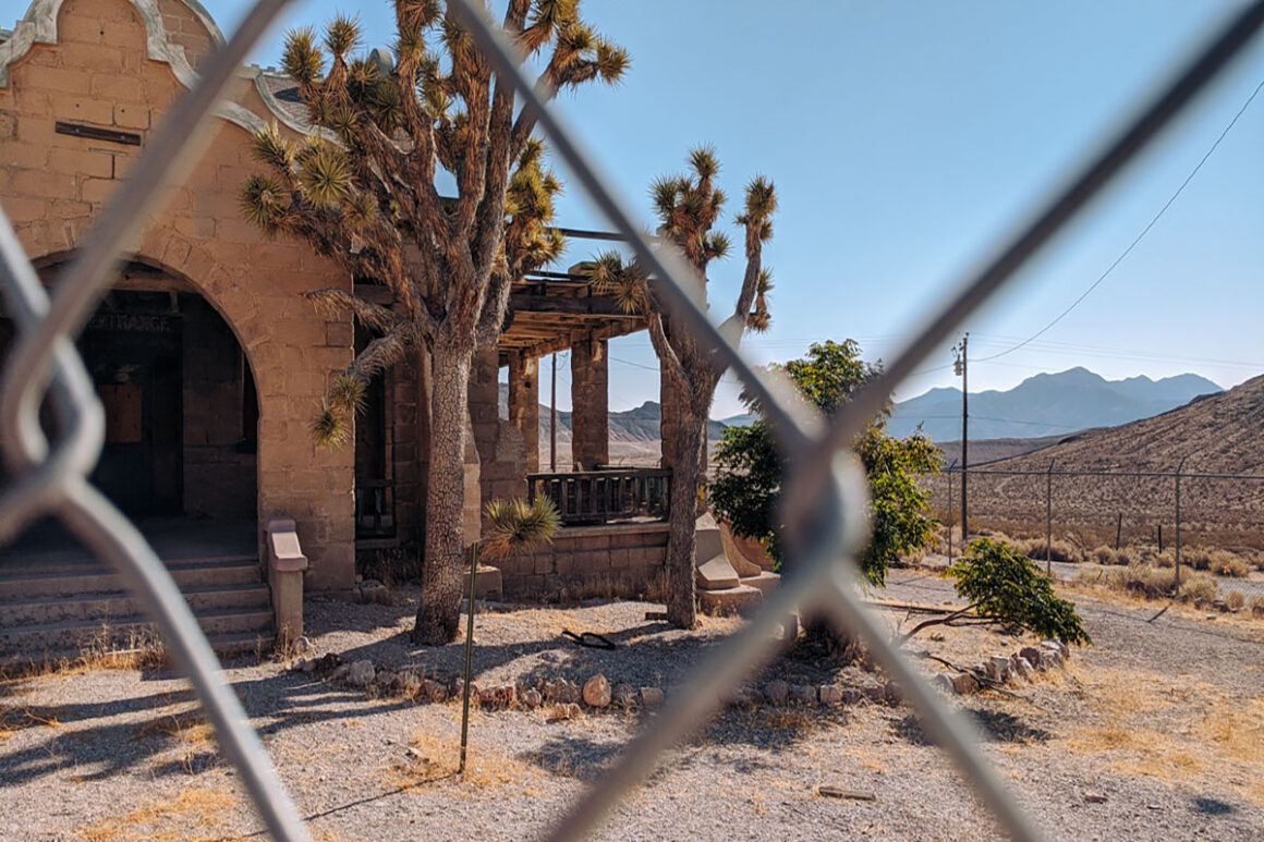
21. Explore the Ghost Town of Rhyolite
Just outside the east entrance of Death Valley near Beatty, Nevada, Rhyolite is one of the best-preserved ghost towns in the American West — and an easy stop if you’re driving in from Las Vegas.
Founded during the Gold Rush in the early 1900s, the town once had banks, a train depot, hotels and even an opera house before quickly collapsing when the mines failed. Today, you can wander past crumbling stone buildings, old railroad remnants and the famous bottle house built entirely from glass bottles.
It’s one of the most interesting stops near Death Valley and an easy addition to a road trip itinerary, especially if you’re entering or leaving the park from the Nevada side.
How to get there:
- Road / Highway: NV-374 just outside the east entrance of the park
- Vehicle Restrictions: None
- Best Time to Visit: Anytime
- Parking:
- Tips / Notes:
- Easy to combine with a Las Vegas → Death Valley road trip
- Good historical context for first-time visitors
- Don’t miss the Tom Kelly Bottle House and Goldwell Open Air Museum nearby
Death Valley Google Map
To help you plan your route, I’ve included a Google Map with layers showing all the stops in this guide, plus a suggested driving route from Las Vegas and a sample itinerary.
You can toggle different layers on and off depending on what you want to see, which makes it easier to plan your day or rearrange stops based on timing and distance.
If you’re logged into Google, you can also save the map to your own account by clicking the star icon. Each stop includes location details so you can easily navigate or get more information while you’re on the road.
How to Use This List
Death Valley National Park is massive, and the biggest mistake visitors make is trying to treat it like a typical national park where everything is close together but in this case it’s not like that.
The stops in this list are spread across long stretches of road, and what you can realistically see in a day depends on how you group them, not just how many you pick.
A good way to think about it is in sections:
- East side highlights (like Dante’s View and Badwater Basin)
- Central valley stops (Furnace Creek, Zabriskie Point, Artist’s Drive)
- Western and remote areas (Ubehebe Crater, Wildrose, and beyond)
Most visitors will naturally focus on one or two of these zones per day instead of trying to cover everything in a straight line. In fact, strategic planning is very important in a park like Death Valley.
Timing also matters just as much as distance. Early mornings and late afternoons are the best times to explore, not just for photos but because temperatures are far more manageable. Midday is usually better for short stops, visitor centers or scenic drives where you stay in the car.
If you only have one day, focus on the central valley highlights and a few easy viewpoints. If you have two or more days, you can start spreading out into the more remote areas and slower-paced stops.
Think of this list less as a checklist and more as a set of building blocks for your own route through the park.
When’s the Best Time to Visit Death Valley?
Spring: Early spring is a terrific time of year to visit Death Valley National Park. The winter crowds have dispersed and temperatures are milder. Late spring, especially after a wet winter, is wildflower season so it can be a bit busier then.
Summer: Average temperatures in summer at Death Valley range anywhere from 110F to 116F, or higher. It’s obvious why it’s not the ideal time for exploring the park, let alone hiking. Not to mention tent camping would be downright miserable in summer.
Fall: Fall is a popular time for visiting Death Valley National Park. Although, in early Fall, temperatures can still be fairly hot. When we visited in October one year, the high temperature was 116F. Unfortunately, we were tent camping and honestly, sleep didn’t come so easy.
Winter: Winter is the busiest time in Death Valley National Park. Temperatures are mild and can range anywhere between 70’s during the day to mid 30’s for the lows. It’s way easier to visit during the winter months since you don’t have to be worried about overheating. The flip side is there will be more people in the park in the winter.
What to Know Before You Go
- When to Go: Death Valley can be visited year-round, but conditions vary dramatically by season. Most travelers prefer the cooler months from fall through spring when temperatures are more manageable for exploring.
- Maps & Navigation: Pick up a park service map at entrance kiosks or the visitor center – or download one here. The National Park Service also has a helpful app for self-guided tours and park info.
- Cell Service: Service is limited throughout the park. Furnace Creek is one of the better spots, but don’t rely on your phone for navigation.
- Fuel: Gas is available at Furnace Creek, Stovepipe Wells, and Panamint Springs – but distances between stations are long, and prices are higher than outside the park. Fill up before entering and top off whenever possible.
- Hydration: Bring plenty of water – at least one gallon per person, per day.
- Vehicle Prep: Make sure your vehicle is in top condition. Check fluids, tires, and ensure your spare is ready, along with tools for a flat.
- Recreate Responsibly: Always use Leave No Trace principles. The desert is more fragile than you think.
Where to Stay in Death Valley National Park
Whether you prefer camping under the stars or the comforts of a hotel, Death Valley has a variety of places to stay. Inside the park there are nine campgrounds and three hotels plus others in the surrounding areas outside the park.
Besides developed campgrounds, there are several primitive campgrounds in the park for those who enjoy less structured camping. Check nps.gov for a current listing of those campgrounds and how to get there. You can also download a backcountry and wilderness map.
Developed campgrounds in the park include:
- Furnace Creek Campground
- Sunset Campground
- Texas Springs Campground
- Stovepipe Wells Campground
- Emigrant Campground
- Wildrose Campground
- Mesquite Spring Campground
Private campgrounds in the park:
- Panamint Springs Campground
- The Ranch at Death Valley
- Ohyu RV Park
Hotels in the Death Valley National Park
For those looking for more luxury – the park’s hotels provide a comfortable overnight after a day of exploring, with options ranging from historic inns to modern lodges. All of the hotels are open all year (weather permitting).
- Panamint Springs Resort
- The Inn at Death Valley
- The Ranch at Death Valley
- Stovepipe Wells Village
FAQ
How much time do you need in death valley national park?
You could see everything on this list in two days but I recommend at least three days — add a fourth if you want time for backcountry areas or longer hikes. If you visit when it’s hot, it’s easy to get tired very quickly.
Why is it Called Death Valley?
The name Death Valley was coined when a group of pioneers almost died in the area in the winter of 1849-1850. When they were finally rescued, one of them turned around, looked back and said “goodbye, death valley” and the name stuck.
What’s the closest city to Death Valley?
Beatty, Nevada, aka, the Gateway to Death Valley is less than 10 miles from the east entrance of the park. If you enter or exit the park at Beatty, be sure to visit Rhyolite, a ghost town located between Beatty and the park.
Final Thoughts on Things to do in Death Valley
Hands down, Death Valley National Park is one of my personal favorite parks in the United States. Even though it’s a bit more difficult to visit because of its conditions, it’s the most magical places I’ve visited — and definitely worth the extra effort.
The good thing about Death Valley is since it’s so close to Los Angeles and Las Vegas, it’s easy to visit on its own, as a day trip, or as part of a longer southwestern Mojave Desert itinerary that includes Joshua Tree National Park and Mojave National Preserve.
See you on the trail!

Author: Lori Blalock
A girl raised in the south, Lori is the founder of Southerner Says and is a travel advisor who’s road tripped all 50 states, visited over half the states in Mexico and more than a handful of Caribbean islands and Central America. Passionate about small towns, national parks, tacos and barbeque, she writes about and helps others plan getaways in North America and beyond. Georgia is home — but she’s rarely there.